 Neuerscheinungen 2012Stand: 2020-01-07 |
Schnellsuche
ISBN/Stichwort/Autor
|
Herderstraße 10
10625 Berlin
Tel.: 030 315 714 16
Fax 030 315 714 14
info@buchspektrum.de |
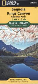
National Geographic Trails Illustrated Topographic Map Sequoia, Kings Canyon National Parks
Waterproof. Tear-resistent. 1 : 80.000
Upd. ed. 2012. 1 S. 965 x 660 mm
Verlag/Jahr: NATIONAL GEOGRAPHIC MAPS 2012
ISBN: 1-56695-298-0 (1566952980)
Neue ISBN: 978-1-56695-298-9 (9781566952989)
Preis und Lieferzeit: Bitte klicken
Kings Canyon Nationalpark mit den Highlights: Giant Sequoia National Monument; John Muir, Golden Trout, Jennie Lake and Monarch Wilderness Areas und der höchsten Stelle USAs
This Trails Illustrated topographic map is the most comprehensive recreational map for California´s Sequoia and Kings Canyon National Parks. Some highlights of the map include Mt. Whitney, Sequoia Grove boundaries, Giant Sequoia National Monument, John Muir, Golden Trout, Jennie Lake and Monarch Wilderness Areas, John Muir Trail and Pacific Crest Trail. This revised map is updated with new shaded relief and contours. The trails have been enhanced and road and trail mileage have been added to create a more usable map for both parks. Includes UTM grids for GPS.