 Neuerscheinungen 2012Stand: 2020-01-07 |
Schnellsuche
ISBN/Stichwort/Autor
|
Herderstraße 10
10625 Berlin
Tel.: 030 315 714 16
Fax 030 315 714 14
info@buchspektrum.de |
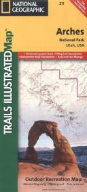
National Geographic Trails Illustrated Map Arches National Park Utah, USA
Outdoor Recreation Map. Mit neuen Wanderwegen und Campingplätzen. 1 : 35.000
2012. 1 S. 965 x 660 mm
Verlag/Jahr: NATIONAL GEOGRAPHIC MAPS 2012
ISBN: 1-56695-327-8 (1566953278)
Neue ISBN: 978-1-56695-327-6 (9781566953276)
Preis und Lieferzeit: Bitte klicken
Karte mit neuen Wanderwegen und Campingplätzen
This map includes Arches National Park, The Highlands, Little Valley, Devils Garden, Lost Spring Canyon Wilderness area, Negro Bill Wilderness area, Scott M. Matheson Wetlands Preserve, Cache Valley, Delicate Arch, Broken Arch, Dark Angel, Double Arch, and more. The map also includes the Colorado River, the Windows Section, Petrified Dunes, and fascinating information about the park´s geology, archaeology, history, and culture. The map has been updated to reflect road closings, new trails, and campground relocation, and more. Includes UTM grids for GPS.