 Neuerscheinungen 2012Stand: 2020-01-07 |
Schnellsuche
ISBN/Stichwort/Autor
|
Herderstraße 10
10625 Berlin
Tel.: 030 315 714 16
Fax 030 315 714 14
info@buchspektrum.de |
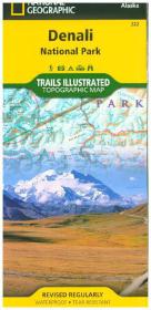
National Geographic Trails Illustrated Map Denali National Park & Preserve, Alaska, USA
Outdoor Recreation Map. Backcountry Units, Denali State Park, Park Entrance & Headquarters Inset Map. 1 : 225.000
2012. 1 S. 965 x 660 mm
Verlag/Jahr: NATIONAL GEOGRAPHIC MAPS 2012
ISBN: 1-56695-328-6 (1566953286)
Neue ISBN: 978-1-56695-328-3 (9781566953283)
Preis und Lieferzeit: Bitte klicken
Karte mit neuen Wanderwegen und Campingplätzen
A necessity for exploring in the outdoors, Trails Illustrated topographic maps are detailed, up-to-date, and printed on waterproof, tear-resistant material. Denali National Park, in the Alaska Range, is crowned by Mount McKinley - America´s highest peak at 20,320 feet. The map includes the entire national park area, with a close-up view of the area in and around Mount McKinley. It also includes useful tips about animal encounters, river crossings, hypothermia, and UTM grids for use with your GPS unit.