 Neuerscheinungen 2012Stand: 2020-01-07 |
Schnellsuche
ISBN/Stichwort/Autor
|
Herderstraße 10
10625 Berlin
Tel.: 030 315 714 16
Fax 030 315 714 14
info@buchspektrum.de |
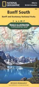
National Geographic Trails Illustrated Topographic Map Banff South
Banff and Kootenay National Parks. Alberta, British Columbia. Waterproof. Tear-resistent. 1 : 100.000
Rev. 2012. 1 S. 965 x 660 mm
Verlag/Jahr: NATIONAL GEOGRAPHIC MAPS 2012
ISBN: 1-56695-658-7 (1566956587)
Neue ISBN: 978-1-56695-658-1 (9781566956581)
Preis und Lieferzeit: Bitte klicken
Karte, beidseitig bedruckt, wasserfest
Trails Illustrated topographic maps are the most detailed and up-to-date recreation maps available for these national parks, national forests and popular outdoor recreation areas. The front side of the Banff South map details the north side of the national park, and also covers survival tips, entry fees and what to do while visiting. The reverse side of the map details the south side of the park, while insets show tips on outdoor ethics, and activities while visiting Kootenay National Park such as backpacking, camping, biking, hiking and the hot springs.