 Neuerscheinungen 2012Stand: 2020-01-07 |
Schnellsuche
ISBN/Stichwort/Autor
|
Herderstraße 10
10625 Berlin
Tel.: 030 315 714 16
Fax 030 315 714 14
info@buchspektrum.de |
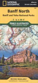
National Geographic Trails Illustrated Topographic Map Banff North
Banff and Yoho National Parks. Alberta / British Columbia. Waterproof. Tear-resistant. 1 : 100.000
Rev. 2012. 1 S. 965 x 660 mm
Verlag/Jahr: NATIONAL GEOGRAPHIC MAPS 2012
ISBN: 1-56695-659-5 (1566956595)
Neue ISBN: 978-1-56695-659-8 (9781566956598)
Preis und Lieferzeit: Bitte klicken
Karte, beidseitig bedruckt, wasserfest
Trails Illustrated topographic maps are the most detailed and up-to-date recreation maps available for these national parks, national forests and popular outdoor recreation areas. The front side of the Banff North map details the south side of the national park, and also covers survival tips, area trails, entry fees and details both Kootenay and Yoho Nationals Parks. The reverse side of the map details the north side of the park, while insets show safe travel in Bear Country, and all the recreation the park has to offer. The map is printed on waterproof, tear-resistant material.