 Neuerscheinungen 2012Stand: 2020-01-07 |
Schnellsuche
ISBN/Stichwort/Autor
|
Herderstraße 10
10625 Berlin
Tel.: 030 315 714 16
Fax 030 315 714 14
info@buchspektrum.de |
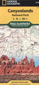
National Geographic Trails Illustrated Map Canyonlands National Park
Topographic Map. Waterproof. Tear-resistent. 1 : 70.000
Rev. 2012. 1 S. 965 x 660 mm
Verlag/Jahr: NATIONAL GEOGRAPHIC MAPS 2012
ISBN: 1-56695-326-X (156695326X)
Neue ISBN: 978-1-56695-326-9 (9781566953269)
Preis und Lieferzeit: Bitte klicken
Karte mit neuen Wanderwegen und Campingplätzen
Included on this map are Canyonlands National Park, the Island in the Sky district, the Needles district, and the Maze district. The map also includes the Colorado River, the Green River, Indian Creek Wilderness, Bridger Jack Mesa Wilderness, Butler Wash Wilderness, Canyon Rims Recreation Area, and fascinating information about the park´s archaeology. Ideal for recreation activities in this beautiful area, including hiking, biking, camping, climbing, photography - any back-country outdoor activity. Includes UTM grids for use with your GPS unit.