 Neuerscheinungen 2013Stand: 2020-01-07 |
Schnellsuche
ISBN/Stichwort/Autor
|
Herderstraße 10
10625 Berlin
Tel.: 030 315 714 16
Fax 030 315 714 14
info@buchspektrum.de |
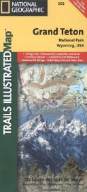
National Geographic Trails Illustrated Map Grand Teton National Park, Wyoming, USA
Hiking Trails, Backcountry Campsites and Zones, Trail Descriptions, Jedediah Smith Wilderness, National Elk Refuge, Detail Map of Grand Teton Area. Outdoor Recreation Map. GPS Compatible. Full UTM Grid
Rev. 2013. 1 S. 965 x 660 mm
Verlag/Jahr: NATIONAL GEOGRAPHIC MAPS 2013
ISBN: 1-56695-437-1 (1566954371)
Neue ISBN: 978-1-56695-437-2 (9781566954372)
Preis und Lieferzeit: Bitte klicken
Grand Teton National Park inkl. Caribou Targhee National Forest, Jedediah Smith Wilderness, Bridger Teton National Forest, John D. Rockefeller Jr. Memorial Parkway, and Gros Ventre Wilderness und Ski-Gebieten
This Trails Illustrated topographic map is the most comprehensive recreational map for Wyoming´s Grand Teton National Park. Coverage includes Fort Meade Recreation Area, Black Hills Experimental Forest, Bridger Teton National Forest, Caribou Targhee National Forest, Deerfield Lake, Jedediah Smith and Gros Ventre Wilderness areas, John D. Rockefeller Jr. Memorial Parkway, Colter Bay Village, Sturgis and Jackson, Snow King Mountain, Jackson Hole Mountain Resort, and Grand Targhee Resort. Also includes UTM grids for use with your GPS unit.